


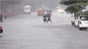
Mumbai is on the brink for an extended spell of pre-monsoon showers through the coming week, with the India Meteorological Department (IMD) forecasting intensified rain activity across Maharashtra due to a low-pressure area developing over the Arabian Sea near the Karnataka coast on May 22.
According to IMD, this system is expected to trigger moderate to heavy rainfall in parts of Mumbai and the Konkan region, continuing till next Sunday. Regardless the yellow alert in place, Saturday saw only scattered light showers across Mumbai, but as per indication by the meteorologists the rain intensity will rise as the system moves closer inland.
The IMD has maintained a yellow alert for Mumbai, Thane, Palghar, and Raigad till Wednesday, excluding Monday, when a green alert indicating light to moderate rain has been issued for the city and neighbouring Palghar.
The first signs of this wet spell were visible on Saturday morning when light to moderate rain swept across various parts of the city between 8 am and 9 am. In the island city, Nair Hospital recorded 14 mm of rain. In the eastern suburbs, rainfall was measured at 12 mm in Kurla and Powai.
On the western side, Khar West witnessed the highest with 20 mm, followed by Bandra West with 18 mm, Jogeshwari at 16 mm, BKC at 14 mm, Marol with 13 mm, and Aarey Colony in Goregaon with 11 mm. IMD’s Colaba observatory registered 8 mm of rainfall in the 24-hour period ending Saturday morning, while the Santacruz station recorded only trace precipitation. The skies remained overcast throughout the day, with humidity levels exacerbating the discomfort for residents.
As per Weather officials have forecast thunderstorms accompanied by lightning and moderate rainfall, w4⁴⁵ith wind speeds reaching up to 50 kmph in isolated pockets of the city and its adjoining districts. The intensifying low-pressure system off the Karnataka coast is likely to energise this weather pattern over the next several days.
In total disregard to the cloud cover and intermittent rain, the city continues to battle elevated temperatures. IMD data reveals Santacruz recorded a high of 34.4°C—0.7°C above the normal average—while Colaba posted a slightly lower high of 34.2°C, 0.2°C above average.
Minimum temperatures also reflected a warming trend in Santacruz at 27.9°C, nearly 0.8°C above normal, though Colaba saw a marginal dip to 26.2°C, slightly below the seasonal norm.
Meteorologists have indicated that the early progress of the southwest monsoon over parts of southern India is a contributing factor to the current weather developments.
As per a senior IMD official, favourable conditions are now in place for the southwest monsoon to advance further into more parts of the south Arabian Sea, Maldives and the Comorin area, as well as sections of the Bay of Bengal over the next three to four days. This shift is expected to influence pre-monsoon activity in western India as well. While the normal onset of monsoon in Mumbai occurs between June 10 and June 15, an earlier-than-usual advance in southern India could potentially accelerate its arrival in Maharashtra. This has significant implications for civic infrastructure readiness, reservoir levels, and urban drainage systems, particularly in densely populated coastal metros like Mumbai, which are often prone to waterlogging and disruptions during heavy rain.
City planners and civic agencies will now be closely monitoring rainfall distribution and the wind system’s trajectory in order to activate pre-monsoon preparedness protocols. Past experiences of extreme rain events have underscored the importance of timely desilting of drains, tree-trimming, structural inspections of ageing infrastructure, and citizen awareness campaigns to prevent urban flooding and service disruption. Climate analysts suggest that Mumbai’s shifting rainfall patterns and early pre-monsoon activity are part of a broader climatic recalibration triggered by global warming and regional weather anomalies. “What we’re seeing is not unusual anymore. Weather systems are evolving more rapidly and are less predictable, which makes real-time observation and localised alerts far more critical,” explained a senior climatologist based in Pune.
For citizens, this means a heightened need for caution while commuting and carrying out outdoor activities, particularly as wind gusts and slippery surfaces may cause hazards. The local transport authority has also advised commuters to allow for delays and to monitor alerts issued through official channels. As Mumbai inches closer to the official monsoon onset, city stakeholders must balance immediate risk management with long-term sustainability goals—reinforcing stormwater drains, expanding permeable surfaces, and safeguarding low-lying and marginalised communities most vulnerable to flood impacts.
While the rains may bring some temporary respite from the heat, they also serve as a litmus test for the city’s climate resilience measures—an increasingly vital agenda in the pursuit of equitable and sustainable urban futures.
News Edit KV Raman
